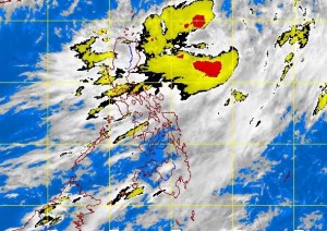
MANILA, Philippines – “Maring” (international name Trami) slightly slowed down as it intensified into a tropical storm Sunday afternoon, the state weather bureau said.
The storm packed maximum sustained winds of 65 kilometers per hour and gusts of up to 80 kph, the Philippine Atmospheric, Geophysical and Astronomical Services Administration said.
It was last observed 560 kilometers east of Itbayat, Batanes, moving east northeast at 7 kilometers per hour.
“Maring” will enhance the prevailing southwest monsoon affecting the whole country.
Monsoon rains are seen in Metro Manila, Ilocos Region, Calabarzon and the provinces of Benguet, Zambales, Bataan and Occidental Mindoro, which may trigger flashfloods and landslides.
Meanwhile, Mindanao, Western Visayas and the rest of Luzon will have cloudy skies with light to moderate rainshowers and thunderstorms. The rest of Visayas will be partly cloudy to cloudy with isolated rainshowers or thunderstorms, Pagasa said.
Moderate to strong winds blowing from the southwest will prevail throughout the archipelago and the coastal waters will be moderate to rough, it added.
