Storm warnings up briefly in North as tropical depression enters PH

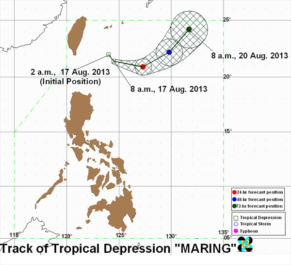
Track of Tropical Depression “Maring”. Photo from pagasa.gov.ph
MANILA, Philippines – Tropical depression “Maring,” the 13th cyclone to enter the Philippines in 2013, struck at the country’s northern parts on Saturday, spawning rains, gusty winds and rough waves in the Batanes area, the state weather bureau said.
Storm Signal No. 1 was raised over the Batanes group of islands on Saturday morning but was lifted by midday.
As of 10 a.m. Saturday, the weather disturbance was observed some 270 kilometers northeast of Itbayat, Batanes, packing peak winds of 55 kilometers per hour near the center, the Philippine Atmospheric, Geophysical and Astronomical Services Administration (Pagasa) said.
The weather said Maring was moving east-southeast at 11 kph.
According to Pagasa’s 24-hour weather outlook, the Batanes group of islands will have rains and gusty winds with moderate to rough seas due to the depression.
Article continues after this advertisementThe regions of Ilocos, Cordillera, Cagayan Valley, Caraga, and Northern Mindanao will experience cloudy skies with moderate to occasionally heavy rain showers and thunderstorms, it added.
Article continues after this advertisementPagasa warned that the heavy rains might trigger flash floods and landslides in those areas.
Metro Manila and the rest of the country will be partly cloudy to cloudy with isolated rain showers or thunderstorms.
Moderate to strong winds blowing from the southwest will prevail over the rest of Luzon and coastal waters in these areas will be moderate to rough, Pagasa said.
Elsewhere, winds will be light to moderate coming from the southwest with slight to moderate seas, it added.
Maring is expected to dump moderate to heavy rainfall (from 5 – 10 millimeters per hour) within its 300-kilometeriwide area of circulation.
The depression will enhance the southwest monsoon, bringing light to moderate rain showers and thunderstorms over the western sections of Northern and Central Luzon, Pagasa said.