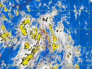
MANILA, Philippines — A low-pressure area in the West Philippine Sea will likely exit within 24 hours but it may still develop into a tropical cyclone while within the Philippine territory, according to the state weather bureau.
The Philippine Atmospheric, Geophysical and Astronomical Services Administration (Pagasa) said the weather disturbance was observed at 250 kilometers west of Ambulong, Batangas, as of mid-Tuesday.
The LPA was embedded in the Intertropical Convergence Zone, which has been bringing rains over most parts of the country, the weather bureau said.
But Pagasa forecaster Alvin Pura said the LPA would be out of the Philippine area of responsibility within 24 hours. It might, however, develop into a depression on its way out over the sea, he added.
If it does, it would be named “Jolina,” the10th tropical cyclone to hit the country in 2013.
Pura said he expected improving weather conditions by Thursday or Friday.
In an advisory, Pagasa said the LPA and the ITCZ would bring cloudy skies with moderate to occasionally heavy rains over Mimaropa (Mindoro, Marinduque, Romblon and Palawan) and Western Visayas, which might trigger flash floods and landslides.
“Residents in these areas are advised to take all the necessary precautionary measures,” Pagasa said.
On the other hand, Metro Manila and the rest of the country would have cloudy skies with light to moderate rain showers and thunderstorms,
Pagasa said.
Moderate to occasionally strong winds blowing from the southwest would prevail over Palawan, Visayas and Mindanao and the coastal waters along these areas would be moderate to occasionally rough, it added.
Light to moderate winds coming from the southwest to southeast would prevail over the rest of Luzon, with slight to moderately rough coastal waters along these areas, Pagasa said.
