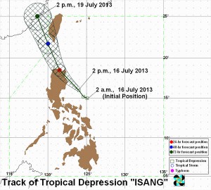
Track of Tropical Depression “ISANG”. pagasa.gov.ph image
MANILA, Philippines – Tropical depression “Isang” slightly intensified as it continued to move towards the Isabela-Cagayan area, the state weather bureau said Tuesday afternoon.
“Isang,” which was last observed 230 kilometers east northeast of Baler, Aurora, is now packing maximum sustained winds of 55 kilometers per hour, the Philippine Atmospheric Geophysical and Astronomical Services Administration said.
The following are areas placed under Signal No. 1:
Aurora
Quirino
Isabela
Ifugao
Mt. Province
Abra
Kalinga
Apayao
Ilocos Norte
Ilocos Sur
Cagayan
Calayan
Babuyan Group of Islands
Batanes Group of Islands
The cyclone moved northwest at 15 kph.
“Aurora, Quirino, Isabela, Mt. Province, Kalinga, Apayao, Ilocos Region, Abra, Ifugao, Batanes Group of islands, Cagayan including Calayan and Babuyan Group of Islands will have rains and gusty winds with moderate to rough seas,” Pagasa’s weather bulletin said.
“Metro Manila, the rest of Luzon, Visayas, Zamboanga Peninsula and Northern Mindanao will experience cloudy skies with light to moderate rainshowers and thunderstorms. The rest of Mindanao will be partly cloudy to cloudy with isolated rainshowers or thunderstorms,” it added.
“Moderate to strong winds blowing from the southwest to southeast will prevail over the rest of Luzon and the coastal waters along these areas will be moderate to rough. Elsewhere, winds will be light to moderate coming from the west to southwest with slight to moderate seas,” Pagasa also said.
Isang will enhance the southwest monsoon and will bring moderate to heavy thunderstorms over Mimaropa, Calabarzon, Bicol Region and Western Visayas.

