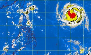
MANILA, Philippines—The cyclone seen inching closer to Philippines has intensified into a typhoon.
“Soulik” was last observed 1,680 kilometers east of Basco, Batanes outside the eastern boundary of the Philippine area of responsibility, the Philippine Atmospheric Geophysical and Astronomical Services Administration said midday Tuesday.
“Soulik,” which will be called “Huaning” once it enters the country, was packing maximum sustained winds of 120 kilometers per hour and gusts of up to 150 kph.
The typhoon was forecast to enter the country Wednesday morning and would exit early morning of Saturday towards Taiwan, forecast models showed.
The typhoon was not expected to hit land but would enhance the southwest monsoon, Pagasa said, adding that rains in the western part of the country would be experienced starting Thursday afternoon.
Meanwhile, an Intertropical Convergence Zone continues to affect Palawan and Mindanao, Pagasa said in its outlook for Wednesday.
Mimaropa (Mindoro, Marinduque, Romblon and Palawan), the Ilocos Region, Zamboanga Peninsula, Soccsksargen (South Cotabato, Cotabato, SultanKudarat, Sarangani and General Santos City), and Northern Mindanao, will experience cloudy skies with light to moderate rain showers and thunderstorms, Pagasa said.
Metro Manila and the rest of the country will be partly cloudy to cloudy with isolated rainshowers or thunderstorms, it said. With a report from DJ Yap, Philippine Daily Inquirer
