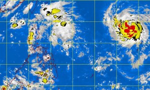
MANILA, Philippines – A tropical cyclone is expected to enter the Philippine territory by Wednesday, the state weather bureau said Monday afternoon.
The Philippine Atmospheric Geophysical and Astronomical Services Administration said the weather disturbance with international name Soulik and will be called “Huaning” once it enters the Philippine area of responsibility has intensified into a tropical storm earlier in the day.
Soulik packed maximum sustained winds of 85 kilometers per hour near the center and gusts of up to 100 kph. It is forecast to move west at 20 kph.
It was last observed 2,010 km east of Basco, Batanes.
Buddy Javier, weather forecaster of Pagasa, told INQUIRER.net that based on forecast models, Soulik will likely stay in the Philippine territory until Saturday.
He added that it will affect areas in extreme northern Luzon such as Batanes as it heads towards Taiwan.
An intertropical convergence zone continues to affect Palawan and Mindanao, the afternoon weather bulletin said.
“Palawan, Western Visayas, Zamboanga Peninsula and Northern Mindanao will experience cloudy skies with light to moderate rainshowers and thunderstorms,” Pagasa said.
Metro Manila and the rest of the country will be partly cloudy to cloudy with isolated rainshowers or thunderstorms.
Light to moderate winds blowing from the east to southeast will prevail over Luzon and coming from the northeast to east over Visayas and Mindanao. The coastal waters throughout the archipelago will be slight to moderate.
