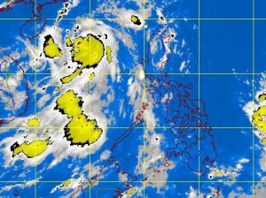
MANILA, Philippines—Tropical storm Gorio (international name: Rumbia) gained more strength and speed even as it made its way out of the Philippine territory early Monday, the state weather bureau said.
Gorio exited the Philippine area of responsibility around 2 a.m. and headed for southern China, the Philippine Atmospheric Geophysical and Astronomical Services Administration (Pagasa) said.
The storm was last observed 560 km northwest of Dagupan City at 4 a.m., packing maximum sustained winds of 85 kilometers near the center and gusts of up to 100 kph.
It moved northwest at 30 kph.
Pagasa still warned fishermen, especially those using small seacraft, not to venture out into the western seaboard of Luzon due to big waves caused by Gorio.
The regions of Ilocos, Mimaropa and the provinces of Zambales and Pangasinan will experience cloudy skies with light to moderate rainshowers and thunderstorms, Pagasa said.
Metro Manila and the rest of the country will be partly cloudy with isolated rainshowers or thunderstorms mostly in the afternoon or evening.
Moderate to strong winds blowing from the southeast will prevail over northern and central Luzon and coming from the southwest to south over southern Luzon and Visayas. The coastal waters along these areas will be moderate to rough. Elsewhere, winds will be light to moderate coming from the southwest with slight to moderate seas, Pagasa said.
