‘Gorio’ may hit Metro Manila; 37 areas under storm signals—Pagasa

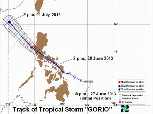
Pagasa shows the path Tropical Storm “Gorio” over the next three days. Gorio is expected to hit Metro Manila early Sunday if it continues its course before exiting through Ilocos Sur on Monday, according to the state-run weather bureau. Storm signals are up in 37 areas around the country.
MANILA, Philippines – Tropical Storm “Gorio” threatens to make a direct hit on Metro Manila early Sunday morning, the state weather bureau said Saturday.
Based on the projected path of the storm, Gorio is seen striking the capital between 6 and 8 a.m., most likely over its southern section, the Philippine Atmospheric, Geophysical and Astronomical Services Administration (Pagasa) said.
On Saturday afternoon, the weather bureau placed Metro Manila and several other provinces in Luzon under Storm Signal No. 2, indicating 61-100 kph winds.
“The central track of the forecast shows that the storm will be moving a little bit towards the southern part of Metro Manila, but again, it may deviate from that track,” forecaster Chris Perez told a news briefing.
“Whether it goes over the southern part or the northern part, we advise the public to continue monitoring the situation,” he added.
Article continues after this advertisementPagasa warned residents of Bicol, Southern Luzon, Central Luzon and Metro Manila to stay alert for flash floods and landslides.
Article continues after this advertisementGorio is predicted to dump moderate to heavy rains at a rate of 5-15 millimeters per hour in places within 150 kilometers around its eye or center.
As of 4 p.m. Saturday, the eye of the storm was observed 40 kilometers southeast of Legazpi City. Gorio made landfall in the town of Hernani in Eastern Samar earlier Saturday, with Mayor Edgar Boco reporting nothing more serious than “just light rains.”
Gorio, the seventh tropical cyclone to enter the Philippine area of responsibility this year, was packing peak winds of 65 kph and gusts of up to 80 kph. It was forecast to move northwest at 24 kph, moving at a brisker pace than six hours earlier, Perez said.
By Sunday afternoon, the storm is expected to be 60 kilometers northwest of Iba, Zambales after hitting Metro Manila in the morning. By Monday afternoon, it will have been 560 kilometers northwest of Sinait, Ilocos Sur, and out of the country’s territory, Pagasa said.
Placed under Storm Signal No. 2 were the following places: Masbate, including Ticao and Burias Islands, Sorsogon, Albay, Camarines Sur, Camarines Norte, Marinduque, Quezon, including Polilio Island, Rizal, Bulacan, Pampanga, Tarlac, Zambales, Nueva Ecija, Pangasinan, Batangas, Laguna, Cavite, Bataan and Metro Manila.
Under Signal No. 1 were Catanduanes, Romblon, Mindoro provinces, including Lubang Island, La Union, Benguet, Nueva Vizcaya, Quirino, Aurora, Samar and Leyte provinces, Biliran, Northeastern Iloilo, Capiz, and Aklan.
Possible effects of Signal No. 2 include moderate damage to crops, uprooting of large trees, and old galvanized iron roofs blown off, while those of Signal No. 1 include broken tree branches, tilted banana plants, and nipa and cogon houses losing their roofs.