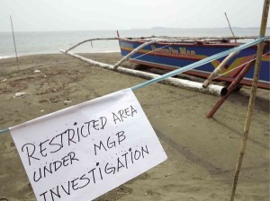
THE MINES and Geosciences Bureau is looking into the erosion of the beach at the village of Uacon in Candelaria, Zambales. ROBERT GONZAGA/INQUIRER CENTRAL LUZON
OLONGAPO CITY, Philippines — The team of geologists sent to investigate what was initially believed to be a sinkhole in Candelaria, Zambales, said the presence of an underground river channel in the area could have caused the collapse of a section of a beach in Barangay (village) Uacon there.
Graciela Macabare, head of the Provincial Disaster Risk Reduction and Management Council in Zambales, said the team, led by the Mines and Geosciences Bureau, conducted shoreline mapping, beach profiling and echo sounding in the area affected by the erosion.
The team members said they “did not find a sinkhole in the waters off Uacon beach,” Macabare said.
Instead, the geologists saw an underground river channel and they surmised that the continuous flow of water hastened the collapse of at least 100 meters of shoreline.
Macabare said the team is still conducting tests and has yet to issue an official report and recommendations to address the erosion, which residents observed on Saturday afternoon.
Residents and patrons of resorts in Uacon were asked not to enter the area, which had been cordoned off, so as not to hamper the work of the team. Swimming was also banned.
“Aside from the initial findings, they have not given any recommendation so far. They need to gather more data and process it in Manila,” Macabare said.
She said the geologists were expected to finish collecting data for their ground and marine study late Thursday.
“What they’re doing now is finding out [the dimensions] and characteristics of the underground river channel. But they assured us that there was no longer any danger in the beach area,” she said.
In a statement, Pancho Caculitan, a marine geologist from the MGB and the supervising science research specialist of the marine investigating team in Uacon, said the sea bottom in the area looked stable.
The river channel was detected through echo-sounding that created a topographic map of the area, he said.