Geologists start probe of sinking Zambales coastline

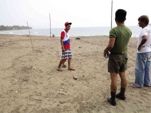
Officials talk to a villager in Uacon about the sinking coastline of the village shortly after the phenomenon was discovered. ROBERT GONZAGA/INQUIRER CENTRAL LUZON
OLONGAPO CITY, Philippines—A team of geologists and disaster response officials has begun studying the appearance of what residents of a coastal village in Candelaria, Zambales, suspect to be a sinkhole, to establish the cause of the ground sinking there on Saturday.
Graciela Macabare, head of the provincial disaster risk reduction and management council in Zambales, said geologists are conducting a marine and ground study following the sinking into the sea of a large portion of the coastline of Barangay Uacon.
“Right now, they are [doing] shoreline mapping, beach profiling and echo sounding,” Macabare told the Inquirer by telephone on Tuesday.
In a TV interview on Tuesday, Mines and Geosciences Bureau (MGB) Director Leo Jasareno said they were looking at either the presence of a sinkhole or coastal erosion as the cause of the ground sinking.
He said the team is using an instrument called “ground penetrating radar.”
Article continues after this advertisementMacabare said the equipment would determine the depth of the water in the study area.
Article continues after this advertisement“It will take time [to establish the cause] because it takes time to cover the whole area,” she said.
She said, however, that the incident poses no danger to the residents.
“We’ll know based on the study if it [was really] a sinkhole. The team has not ruled that out,” she said.
Candelaria Mayor Jean Moraña said village officials had told her the sinking had stopped.
Bernard Barrera, Uacon village chief, said villagers also felt relieved that geologists had started looking into the cause of the sinking.
Barrera said the team is taking pictures of the entire area and dipping tools in the water for various tests.
Lawyer Danilo Uykieng, MGB director in Central Luzon, said their initial investigation showed that the affected area is 80 to 100 meters wide.
Nelson Castro, provincial environment and natural resources officer in Zambales, said although his office has no technical capability to help the team, his office is helping in terms of logistics.
He said the team agreed to release bulletins when there are significant developments in the study. “But so far, there has been none,” he said.
He said access to the area is restricted to members of the investigating team.
Residents and patrons of resorts in Uacon are not allowed to enter the area to ensure the unhampered work of the team.
Environment Secretary Ramon Paje told the Inquirer that he had given the team until Wednesday to finish the tests and provide a scientific explanation for the incident.