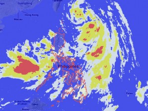
MANILA, Philippines—Tropical storm Emong slightly intensified as it hovered over Batanes area, the state weather bureau said early Wednesday.
Emong was last plotted 420 kilometers east of Basco, Batanes, with maximum sustained winds of 75 kilometers per hour near the center and gusts of up to 90 kph, the Philippine Atmospheric Geophysical and Astronomical Services Administration said.
It maintained its speed and continued to move north at 19 kph.
Emong is expected to be out of the Philippine area of responsibility by Thursday evening.
Residents in Luzon were also warned of flashfloods and landslides as cloudy skies with moderate to heavy rainshowers and thunderstorms are forecast for Wednesday.
Meanwhile, Visayas, Zamboanga Peninsula, Northern Mindanao and Caraga will have cloudy skies with light to moderate rainshowers and thunderstorms. The rest of Mindanao will be partly cloudy to cloudy with isolated rainshowers or thunderstorms, Pagasa said.
Jori Loiz, weather forecaster from Pagasa, told INQUIRER.net that a low pressure area is likely to form over the southern part of the West Philippine Sea.
Moderate to strong winds blowing from the southwest will prevail throughout the archipelago and the coastal waters will be moderate to rough, Pagasa said.
