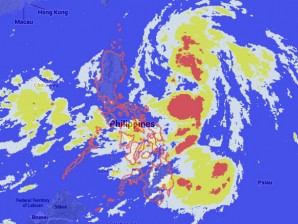
MANILA, Philippines—Tropical depression Emong has maintained its strength as it moves north northwest with maximum sustained winds of 55 kilometers per hour near the center, the state weather bureau said earlyTuesday.
The Philippine Atmospheric Geophysical and Astronomical Services Administration said the cyclone was last observed 460 kilometers east of Baler, Aurora.
It is forecast to move north northwest at 15 kph.
Meanwhile, the heavy rains on Monday night in Metro Manila were caused by southwest monsoon, the prevailing weather system during rainy season, that was enhanced by Emong, Pagasa said. The rains caused heavy traffic and floods in several major Metro Manila thoroughfares. The Armed Forces of the Philippines had to deploy three M-35 trucks along EDSA and Fairview in Quezon City to provide transport to stranded commuters.
Although it was earlier said that Emong is not likely to make a landfall throughout its stay, it will bring moderate to occasionally heavy rains in parts of the country, Pagasa said. It is expected to be out of the Philippine territory by Friday.
“Metro Manila, Central Luzon, Calabarzon, Mimaropa, Bicol Region, Visayas, Northern Mindanao and Caraga will experience cloudy skies with light to moderate rainshowers and thunderstorms. The rest of the country will have partly cloudy to cloudy skies with isolated rainshowers or thunderstorms,” Pagasa said.
“Moderate to strong winds blowing from the southwest to west will prevail over Luzon and Visayas and coming from the southwest over Mindanao. The coastal waters throughout the archipelago will be moderate to rough,” it added.
