‘Emong’ intensifies

The low pressure area (LPA) estimated east of Surigao City has developed into a tropical depression and was named “Emong,” the state weather bureau said Sunday afternoon.
QUEZON CITY, Philippines – Tropical depression “Emong” slightly intensified as it moved north northwest, the state weather bureau said Monday.
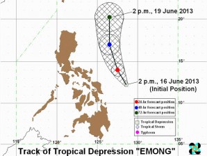
“Emong” was last plotted 300 kilometers east of Virac, Catanduanes with maximum sustained winds of 55 kilometers per hour near the center at 4a.m., the Philippine Atmospheric Geophysical and Astronomical Services Administration said.
It was forecast to move north northwest at 13 kph.
No public storm signals were raised, Pagasa said.
Alvin Pura, weather forecaster of Pagasa, told INQUIRER.net that “Emong” was not likely to make landfall throughout its stay here until the weekend.
Article continues after this advertisement“Ang track nya ay babaybayin nya lang ang East of Luzon hanggang umakyat pa-Taiwan,” he said.
Article continues after this advertisementWeather models also indicated that a low pressure area was also likely to form over the West Philippine Sea by Thursday, Pura added.
Although “Emong” was too far to directly affect any part of the country,it would bring moderate to occasionally heavy rains and thunderstorms over Southern Luzon, Visayas and Mindanao.
“MIMAROPA, Bicol Region, Visayas, Northern Mindanao and Caraga will experience cloudy skies with moderate to occasionally heavy rainshowers and thunderstorms which may trigger flashfloods and landslides,” Pagasa said in its weather bulletin.
Meanwhile, Metro Manila and the regions of Ilocos, Calabarzon, the provinces of Zambales and Bataan and the rest of Mindanao will be cloudy with light to moderate rainshowers and thunderstorms. The rest of Luzon will have partly cloudy to cloudy skies with isolated rainshowers or thunderstorms,it added.
“Moderate to strong winds blowing from the southwest to southeast will prevail over Luzon and coming from the southwest to west over Visayas and Mindanao. The coastal waters throughout the archipelago will be moderate to rough,” Pagasa said.