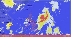
‘Dante’ moves away, heavy rains continue

“Dante” was last spotted 850 kilometers from Aparri, Cagayan as of 4 a.m. Sunday, packing maximum sustained winds of 65 kilometers per hour and gusts of up to 80 kph. It is seen to move northeast at 15 kph, the Philippine Atmospheric Geophysical and Astronomical Services Administration (Pagasa) said.
While it is too far to directly affect any part of the country, it will continue to enhance the southwest windflow that will bring rains and thunderstorms over Southern Luzon, Visayas and Mindanao, it added.
It will bring moderate to heavy rains within its 350 km diameter.
A low pressure area also being monitored by Pagasa, meanwhile, was last observed 460 kilometers east of Borongan City, Eastern Samar and is embedded along the intertropical convergence zone which will affect Bicol region, Visayas and Mindanao.
“Metro Manila, Central Luzon, Calabarzon, Mimaropa and Western Visayas will experience cloudy skies with moderate to heavy rains and thunderstorms which may trigger flash floods and landslides. Bicol Region and the rest of Visayas will have cloudy skies with light to moderate rain showers and thunderstorms. Northern Luzon and Mindanao will be partly cloudy with isolated rain showers or thunderstorms mostly in the afternoon or evening,” Pagasa said.
Article continues after this advertisementModerate to strong winds blowing from the southwest to west will prevail over Northern and Eastern Luzon and the coastal waters along these areas will be moderate to rough. Elsewhere, winds will be light to moderate coming from the southwest will prevail with slight to moderate seas, it added.