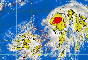
MANILA, Philippines — A new weather disturbance near Palawan is being monitored by the state weather bureau, while tropical depression “Dante” maintains its strength as it moves north-northeastward.
The potential cyclone was last seen 100 kilometers north of Puerto Princesa City and will bring moderate to heavy rains over Palawan, especially the northern part, the Philippine Atmospheric Geophysical and Astronomical Services Administration said midday Saturday.
Meanwhile, even as “Dante” is too far to directly affect any part of the country, it will enhance the southwest windflow that will bring rains and thunderstorms over Southern Luzon, Visayas and Mindanao.
Dante was last seen 740 kilometers east of Casiguran, Aurora as of 10 a.m., packing maximum winds of 45 kilometers near the center. It was moving north-northwest at 15 kph, Pagasa said.
While no storm signals were raised, it will bring moderate to heavy rains within its 300-km diameter.
Dante is forecast to be 920 kilometers east-northeast of Aparri, Cagayan by Sunday morning; 1,060 km northeast of Basco, Batanes by Monday morning and 1,180 km northeast of Basco, Batanes by Monday evening.
