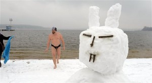
A swimmer gets out of the water next to a snowman with bunny ears at the snow covered beach of Strandbad Lake Wannsee lido in Berlin, Germany, Good Friday March 29, 2013. Bathing season at the lido traditionally starts on Good Friday. AP/dpa, Rainer Jensen
STOCKHOLM— Is it Easter or Christmas? Many Europeans would be forgiven for being confused by winter’s icy grip on lands that should be thawing in springtime temperatures by now.
Britain is on track for the coldest March since 1962, according to national weather service the Met Office, which also says daily low temperatures in London are going to remain below freezing through the Easter holiday. The mean temperature in Britain from March 1-26 was 2.5 C (36.5 F) — three degrees below the long-term average.
In Berlin, Good Friday saw a new round of snowfall and temperatures just above freezing. The city’s popular lakeside beach opened for the season as planned, though it wasn’t exactly beach weather. Some visitors built a snowman and few ventured into the freezing water.
What’s going on?
As always when you talk about weather, natural variability is a big factor. But an increasing body of research suggests that cold spells like the one that has lingered in northern and central Europe for much of March could become more common as a result of global warming melting the Arctic ice cap.
Q: Why is it so cold in much of Europe right now?
A: Normally, European winters are kept relatively mild by wet, westerly winds from the Atlantic. But in March, the wind has been blowing mostly from the northeast, bringing freezing Arctic air down over much of Europe.
Q: So why are the winds coming from the northeast?
A: The winds are driven by atmospheric circulation patterns which in turn are affected by differences in air pressure between northern and southern latitudes. For much of March this circulation has been in a negative state, meaning the pressure difference is small. That weakens the westerly Atlantic winds and paves the way for cold air to sweep down over Europe from the Arctic and Siberia.
Q: What does that have to do with Arctic sea ice?
A: Global warming is melting the ice cap over the Arctic Ocean. Last September, it reached its lowest extent on record. Climate models show that the loss of sea ice — which acts as a lid on the ocean, preventing it from giving off heat — triggers feedback mechanisms that shake up the climate system further. A series of studies in recent years have shown that one such effect could be changes in atmospheric circulation, resulting in more frequent cold snaps in Europe.
Q: How would melting Arctic ice lead to cold snaps?
A: The theory is the loss of sea ice means more heat is released from the open ocean, warming the layer of polar air over the water. That reduces the temperature and air pressure differentials with more southern latitudes, increasing the likelihood of a negative state in the atmospheric circulation. Experts stress that winter weather is affected by many other factors, but several studies have shown the Arctic melt loads the dice in favor of colder and snowier winters in Europe. One study by scientists at the Potsdam Institute for Climate Impact Research in Germany showed European cold snaps could become three times more likely because of shrinking sea ice.
Q: What’s the impact on the jet stream?
A: Some studies suggest that the shrinking sea ice also shifts the polar jet stream, a high-altitude air current that flows from west to east. Bigger waves in the meandering jet stream allow frigid air to spill southward from the Arctic, they say. Other climate experts are uncertain about this effect, saying more research is needed.