New low pressure area named Mina might come in Sunday
[jwplayer mediaid=”34209″]
MANILA, Philippines—“Expect another rainy and cloudy week as another low pressure area is sighted in the Pacific on Wednesday, August 3. We call it Mina. If there are no changes, Mina could turn into a tropical depression and might enter the Philippine Area of Responsibility by Sunday, August 7.” Department of Science and Technology (DOST) Usec. Graciano Yumul told “In Desk Corner” on 990 AM Radyo Inquirer at 6:30 a.m. Monday.
Interviewed by co-anchors Willy Matawaran and Louie Garcia of “In Desk Corner”, Usec. Yumul said Mina might enter through the Bicol Region, which is still yet to recover from damage wrought by Typhoons Kabayan and Juaning.
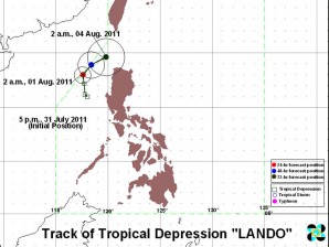
Usec Yumul gave this warning as Typhoon Kabayan leaves through West Philippine Sea while Tropical Depression Lando was estimated at 280 km West of Sinait, Ilocos Sur with maximum winds of 45 kph near the center. It is forecast to move North Northwest slowly, according to the latest bulletin (5 .m. Monday) from the Philippine Atmospheric Geophysical and Astronomical Service Administration (Pagasa).
Pagasa also warned that “the western sections of Luzon and Visayas will experience monsoon rains which may trigger flash floods and landslides.”
Western section of Luzon includes the National Capital Region.
Pagasa added: “The rest of Luzon and Visayas will have mostly cloudy skies with scattered rainshowers and thunderstorms. Mindanao will be partly cloudy to at times cloudy with isolated rainshowers or thunderstorms.
“Moderate to strong winds blowing from the Southwest to west will prevail over Northern Luzon and coming from the Southwest over the rest of the country. The coastal waters throughout the archipelago will be moderate to rough.”
For more updates, listen to 990 AM Radyo Inquirer.
