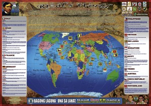
RIZAL MAP The Laguna provincial government has launched educational maps that are commemorative of Jose Rizal’s life and works during his five-year study and trips abroad. CONTRIBUTED PHOTO
SAN PEDRO, Laguna—It’s “Rizal’s world.” The Laguna provincial government is coming out with a new version of educational maps that feature the life and works of national hero Dr. Jose Rizal.
Rizal’s World is basically a world map that highlights the 13 countries, including the Philippines, that Rizal had set his foot on from 1882 to 1887.
Provincial Board Member Neil Nocon, who chairs the board’s committee on education, tourism, history, arts and culture which initiated the project, said the maps were intended to provoke a “global perspective” among Filipinos.
In June, Nocon’s office came out with a map of Laguna featuring the towns associated with Rizal at some point in history.
“With this one, we want to inspire students or Filipinos studying, working or traveling abroad to be like Rizal, and use all those learning and ideas you learned abroad to help improve your own country,” the official said.
The maps teach students not only world geography—as Rizal’s route is traced from the Philippines to Italy, Spain, France, Germany, Vietnam, Sri Lanka, Singapore, Egypt, Yemen, Austria, Czech Republic and Switzerland—but also history as accounts of the hero’s activities in a particular time and city are retold.
‘Remarkable phase’
In a brief narrative (also printed on the map), Dwight David Diestro, an associate professor of history of the University of the Philippines Los Baños, said the period of 1882-1887 was a remarkable phase of Rizal’s life as he transitioned “from relative obscurity to national fame.”
He said it was within this time frame that Rizal produced his most remarkable opus, “Noli Me Tangere,” but, “ironically, he experienced honing his genius outside the country.”
“His five-year stay out of the country made the Philippines, his homeland even closer to him … Being far away did not make him lose his grounding. For example, while approaching Singapore, Rizal saw an island and he immediately thought how similar it was with Talim and Mt. Susong Dalaga (in Rizal province) in terms of appearance,” Diestro wrote.
“Being outside was a form of adaptation or strategy. His life can be summarized in this way, a departure did not mean separation but a journey that made the country clearer and well defined as a future destination and a project for fulfillment.”
Diestro, with former National Historical Institute (NHI) director Dr. Serafin Quiason and a team of researchers, put together the facts based on the books “Rizal Pictorial Calendar” of Teofilo Montemayor and “Quotations from Rizal’s Writings” of the NHI.
Humanizing Rizal
Nocon believed the maps would be an effective teaching aid for students to easily “digest” history. He said it would appeal to the many overseas Filipino workers to know that their national hero was once where they are right now.
“(The map) also humanizes Rizal, that in his course of initiating reform, he too was an ordinary man like us,” he said.
For instance, one entry tells about Rizal eating boiled rice, chicken adobo, fried fish and roast pig with his bare hands in a luncheon and dinner with Filipinos on Feb. 13, 1883, in Madrid, Spain.
Another tells about Rizal playing chess with boat passengers as they were en route to Spain from Manila on May 6, 1882.
“Maybe this can inspire students that they can also excel in sports other than basketball or boxing,” Nocon said.
The provincial government printed out 10,000 copies of the glossy and vibrant maps (2.5 by 3.5 meter) that were launched during the Rizal Day commemoration on Dec. 30 last year before they were handed over to the Department of Education for distribution to public elementary and high schools in Laguna.
Nocon said a second version of Rizal’s World would feature the hero’s life abroad from 1888 to 1892.

