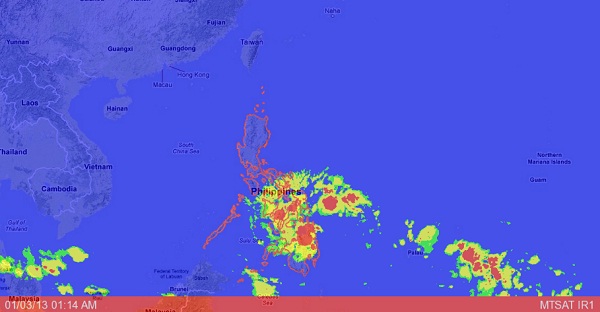
A low pressure area (LPA) spotted east of Mindanao on Tuesday has a slim chance of turning into a storm but the weather bureau is not discounting the possibility it could grow stronger while it is over the Pacific Ocean.
The Philippine Atmospheric Geophysical and Astronomical Services Administration (Pagasa) said the LPA was moving too fast and thus, had a “very low probability of developing into a tropical cyclone.”
As of Wednesday morning, the disturbance was estimated at 790 kilometers east of Mindanao.
“The LPA is expected to bring moderate to heavy rains (2.5-10.0 millimeters per hour) and thunderstorms to Mindanao and the provinces of Samar and Leyte and may trigger flash floods and landslides,” said Pagasa in a bulletin.
Residents of the areas were advised to “take all necessary precautionary measures.”
Pagasa also issued a special advisory for residents of Compostela Valley and Davao Oriental, the two provinces in Mindanao most heavily hit by deadly Typhoon “Pablo” early in December.
The two provinces, according to Pagasa, will be cloudy and experience moderate to heavy rains on Thursday. “Winds will be light to moderate with slight to moderate seas,” it advised.
Pagasa forecaster Manny Mendoza said the LPA was expected to make landfall at about 3 a.m. on Thursday in the vicinity of Agusan del Sur and Davao Oriental.
“We at Pagasa cannot discount the possibility that this can still become a storm because it is still over the water. As in the case of (Tropical Storm) ‘Quinta,’ which started out as an LPA, we did not anticipate that it would become a depression and even a tropical storm,” he said.
The first storm of 2013 will be given the local name “Auring.”
The Philippine Coast Guard (PCG) meanwhile has directed its units to prepare for the weather disturbance that entered the Philippine area of responsibility before noon on Wednesday.
PCG commandant Rear Adm. Rodolfo Isorena placed all Coast Guard units that will be directly affected by the LPA on full alert.
