Bicol braces for ‘Pablo’
LEGAZPI CITY, Philippines – Disaster authorities in Bicol are on heightened alert and getting ready with their disaster contingency plan as Typhoon Bopha is expected to enter the Philippine Area of Responsibility (PAR) either Sunday evening or early morning Monday.
Typhoon Bopha (international name) will be named “Pablo,” the 16th weather event to enter the country this year, according to the Philippine Atmospheric Geophysical and Astronomical Service Administration (Pagasa).
Landrico Dalida, Pagasa regional director for Southern Luzon, told members of the Bicol Regional Disaster Risk Reduction and Management Council (RDRRMC) and Albay PDRRMC in a joint emergency meeting on Saturday that Typhoon “Pablo” will have an intensity of a super typhoon similar to typhoons “Reming” that hit Bicol in 2006; “Sendong,” which hit Mindanao last year; and “Ondoy,” which inundated most of Metro Manila in 2009.
Dalida said Typhoon “Pablo” is expected to gain strength as it moves towards west of Mindanao and southern Visayas, affecting areas that include the Bicol region.
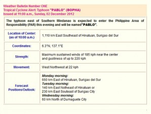
In a worst case scenario, Typhoon “Pablo” by Monday is expected to bring a maximum sustained winds and gustiness of 238 kilometers per hour (kph) with an estimated diameter of 700 kilometers, intense rainfall of 300 to 400 mm, and a speed of 22 kph.
Article continues after this advertisementDalida said Typhoon “Pablo” developed its intensity in an unusual and unique manner called “corioles effect” as it developed five degrees north-south of the equator. “Corioles effect – meaning the weather event had developed in an area where it should not have evolved.”
Article continues after this advertisementDalida said Typhoon “Pablo” is expected to hovers over Bicol on Wednesday affecting the provinces of Masbate, Sorsogon, Albay, Camarines Sur and Camarines Norte. Strong winds and heavy rains will prevail in these areas and storm surge as high as 6 meters would occur in coastal areas in the eastern seaboard of the region, he said.
Disaster authorities in these provinces would then have to watch out for flooding, landslides and storm surges, prompting the RDRRMC to place on red alert status the whole of Bicol region effective Saturday.
Bernardo Alejandro, director of the Office of Civil Defense (OCD) and RDRRMC, said their operation center is now open round-the-clock until the typhoon passes, with the Departments of Social Welfare and Development (DSWD) and of Health (DOH) likewise readying relief and medical supplies and the military and police preparing trucks and personnel for immediate dispatch in case of evacuations.
Albay Gov. Joey Salceda activated on Saturday all disaster councils across the 15 towns and three cities of the province and reminded them of Capitol’s “zero casualty” goal during periods of disaster.
He said activities for the “Karangahan Green Christmas,” a November 25 to December 25 program that discourages use of firecrackers and plastic Christmas decorations, have been put on hold until further notice.
Salceda said they would implement on Tuesday the preventive evacuation of some 350,000 people living in flood, landslide and storm surge prone areas.
At least P54 million calamity fund, he said, is available for this emergency.
At 4:00 p.m. Sunday, the eye of Typhoon Pablo was located based on satellite and surface data at 970 km Southeast of Hinatuan City (06.4 °N, 135.6 °E) with maximum sustained winds of 185 kph and gustiness of up to 220 kph. It is forecast to move West Northwest at 22 kph.
