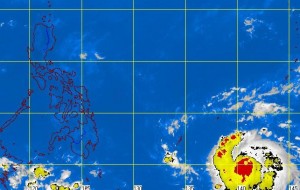
MANILA, Philippines – A storm in the Pacific Ocean that is approaching the Philippines has intensified into a typhoon and will likely enter the so-called Philippine area of responsibility early Monday morning, the state weather bureau said Saturday.
As of Saturday morning, the typhoon, internationally named “Bopha,” was over the Caroline Islands north of Papua New Guinea, some 1,690 kilometers east of Mindanao or 730 kilometers east of the imaginary line denoting the outer edge of the Philippine area of responsibility, the Philippine Atmospheric, Geophysical and Astronomical Services Administration said.
It was packing sustained winds of 165 kilometers per hour near the center and gusting up to 200 kph, Pagasa said in an advisory. The typhoon was moving west at 20 kph.
Bopha will be called “Pablo” locally when it enters the country’s area of responsibility.
“Typhoon ‘Bopha’ is expected to enter the Philippine area of responsibility early morning of Monday east of Mindanao,” Pagasa said.
But the weather bureau added that the storm was still too far to affect any part of the country “within the next two days.” Even so, Pagasa advised disaster managers to be on the alert.
In its weather outlook for Saturday, Pagasa said the Bicol region, eastern Visayas and Mindanao will have partly cloudy skies with isolated brief rain showers or thunderstorms.
Metro Manila and the rest of the country will experience fair weather, it said.
“Moderate to strong winds blowing from the northeast will prevail over Luzon and over the eastern sections of Visayas and Mindanao, and the coastal waters along these areas will be moderate to rough,” Pagasa said.
Elsewhere, winds will be light to moderate coming from the northeast with slight to moderate seas, it added.
