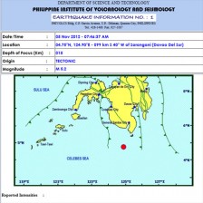
MANILA, Philippines—Three “moderate” earthquakes rocked Davao del Sur Monday morning but these were only slightly felt in the province, the Philippine Institute of Volcanology and Seismology said.
Jane Punongbayan, Phivolcs supervising science research specialist, told the Inquirer that the three earthquakes—each measuring around 5.0-magnitude—that hit the province could have generated a similar intensity had its epicenter been located inland.
“The epicenter is 90 kilometers off the province, somewhere in the middle of the sea. That is too far from land. The most that can be felt then could be Intensity 1 or 2,” she explained.
Under the Phivolcs Earthquake Intensity Scale, Intensities 1 and 2 are hardly felt. An Intensity 5 is generally strong and could cause panic once felt as its force could violently rock structures.
Punongbayan added that the series of earthquakes was probably caused by the “deformation of subducted plates in the area, particularly the Halmahera and Sangihe plates. It is part of a complex subduction process.”
Subduction is a process that occurs on convergent boundaries when a tectonic plate moves under another and sinks into the mantle upon convergence.
Punongbayan clarified that the earthquakes happened at the boundary of the country’s waters and of Indonesia. She said that two 5.3-magnitude earthquakes recorded in Kepulauan, Sangihe, Indonesia, by the US Geological Survey pertained to the same seismological events in Davao del Sur.
Based on Phivolcs Seismological Observation and Prediction Division, the first earthquake was recorded at magnitude 4.9 at around 12:28 a.m. Monday, with its epicenter at 14 kilometers northeast of Sarangani town, Davao del Sur, and had a depth of 141 km.
At around 7:46 a.m., a magnitude-5.2 tremor shook the province. Its epicenter was traced at 99 kilometers southwest of the same town and a depth of 15 km.
An hour later, at around 8:55 a.m., a magnitude-5.1 earthquake was recorded with its epicenter at 90 km southwest of Sarangani town and a depth of 13 km.
Punongbayan said that while no damage to property was reported, aftershocks were to be expected.
