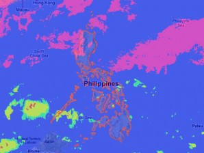
MANILA, Philippines – A potential storm was spotted off east of Southern Mindanao, the state weather bureau said Monday.
The low pressure area (LPA) was seen 865 kilometers east of Southern Mindanao and it will be named “Ofel” when it becomes a cyclone, the Philippine Atmospheric Geophysical and Astronomical Services Administration (Pagasa) said.
Meanwhile, an Intertropical Convergence Zone affecting Visayas and Mindanao was embedded along the LPA.
The ITCZ is a merge of winds from the northern and southern hemispheres which becomes a breeding ground for potential cyclones.
“Visayas and Mindanao will be cloudy with moderate to heavy rainshowers and thunderstorms which may trigger flashfloods and landslides. Bicol region and Mimaropa will have occasional light to moderate rainshowers or thunderstorms,” Pagasa said.
“Metro Manila and the rest of Luzon will be partly cloudy with brief rainshowers or thunderstorms,” it added.
Moderate to strong winds blowing from the northeast will prevail over Luzon and Visayas and the coastal waters along these areas will be moderate to rough. Elsewhere, winds will be light to moderate coming from the northeast to north with slight to moderate seas.
