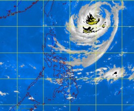
Expect more rains, although Typhoon “Nina” is expected to exit the country much earlier.
Nina (international name: Prapiroon) has gained speed and may well be outside the Philippine area of responsibility (PAR) by this afternoon.
The Philippine Atmospheric, Geophysical and Astronomical Services Administration (Pagasa) said that as of Monday afternoon, Nina had slightly weakened, packing maximum sustained winds of 130 kph near the center and gustiness of 160 kph, from its previous 140 kph to 170 kph force.
As of 4 p.m. Monday, the eye of the typhoon was estimated at 870 km northeast of Itbayat, Batanes.
Weather forecaster Julie Nimes said Nina had gained speed and was moving at a steady 5 kph northwest.
The typhoon’s increased speed, Nimes explained, meant it could be out of the PAR earlier than forecasted, based on its extremely slow movement on Sunday.
Rainfall is estimated to range from heavy to intense (10 mm to 20 mm per hour) within the 600-km diameter of the typhoon in northern Luzon.
According to the weather bureau, Mindanao is expected to have light to moderate rain showers or thunderstorms, while Metro Manila and the rest of the country is anticipated to have partly cloudy skies with brief rain showers or thunderstorms.
