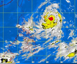
Moving slowly westward, typhoon “Nina” is expected to linger in the Philippine area of responsibility until the weekend, but is not likely to hit land, the state weather bureau said Tuesday.
At 4 p.m. Tuesday, the eye of the typhoon was seen at 1,000 kilometers east of Aparri, Cagayan, packing maximum sustained winds of 120 kph and gustiness of up to 150 kph, the Philippine Atmospheric, Geophysical and Astronomical Services Administration (Pagasa) said.
“It is forecast to move west at 7 kph,” Pagasa said in an advisory. No public storm warning signals were raised as the typhoon was still too far away.
Weather forecaster Jori Loiz said Nina should be out of the country by Saturday or Sunday.
In its weather outlook, Pagasa said Bicol region, Visayas and the Zamboanga peninsula will experience occasional light to moderate rains or thunderstorms.
Metro Manila and the rest of the country will be partly cloudy with brief rain showers or thunderstorms.
