Rain drenches Metro Manila as storm approaches

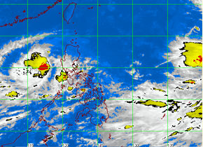
MTSAT ENHANCED-IR Satellite Image as of 1:32 p.m., 03 October 2012
MANILA, Philippines—Heavy intermittent rains pelted Metro Manila and other western parts of the country on Wednesday, signaling the approach of Tropical Storm Marce, but the state weather bureau predicted the storm would leave by Friday.
The Philippine Atmospheric, Geophysical and Astronomical Services Administration (Pagasa) twice issued yellow or heavy rainfall warning over Metro Manila in the morning and at midday on Wednesday after Marce intensified while moving southeastward.
At 10 a.m., the eye of the storm was observed some 270 kilometers west of Iba town in Zambales, packing maximum sustained winds of 85 kph near the center and gustiness of up to 100 kph, Pagasa said. It was forecast to move southeast at a slow 7 kph.
By Thursday morning, the storm is expected to be 455 kilometers west of Ambulong, Batangas, and by Friday morning, 650 kilometers west of Metro Manila, outside the Philippine area of responsibility.
Numerical models showed there was only a small chance Marce would hit land, and that it would likely curve or “make a U-turn” and exit toward Vietnam, Pagasa forecaster Aldczar Aurelio said.
Article continues after this advertisementIf it makes landfall, the storm will affect Zambales or Bataan, he said. He added that the southwest monsoon (locally known as “habagat”) enhanced by the storm will continue to bring moderate to heavy rains to Luzon, including Metro Manila, and the Visayas.
Article continues after this advertisementMarce is seen to spawn moderate to intense rainfall, falling at 10-25 mm per hour, over an area within 200 km of its center, Pagasa said.
Besides Metro Manila, occasional moderate to heavy rains are expected over Central Luzon, Mimaropa (Mindoro, Marinduque, Romblon, Palawan), Calabarzon (Cavite, Laguna, Batangas, Rizal, Quezon) and Bicol.
Fishing boats and other small seacraft were advised not to venture out to sea off the western seaboard of Luzon due to big waves generated by the storm.