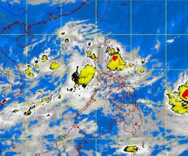
The Philippine Atmospheric, Geophysical and Astronomical Services Administration (Pagasa) is closely monitoring a low pressure area (LPA) that could develop into a tropical depression as it slowly moves toward the Philippine area of responsibility (PAR).
Weather forecaster Samuel Duran told the Inquirer the LPA was spotted over the West Philippine Sea, some 670 kilometers west of Luzon.
“It is moving closer to the PAR although it is almost stationary. The LPA could intensify and enter the PAR,” the weather forecaster said.
He said the LPA could either develop into a tropical depression or dissipate. Should it intensify into a tropical depression upon entering the PAR, it would be called “Marce.”
On the other hand, the monsoon trough, which is in effect over Luzon, is anticipated to bring occasional moderate to heavy rains and thunderstorms over Cagayan, Isabela and the Cordillera Administrative Region.
The trough would also bring occasional light to moderate rains and thunderstorms over Metro Manila, Central Luzon, the Ilocos region and the rest of the Cagayan Valley.
Duran explained that the monsoon trough is an extension of the intertropical convergence zone.
Pagasa said the surge of strong to gale force winds brought by Typhoon “Lawin” (international name: Jelawat), which has left the PAR, had weakened.
