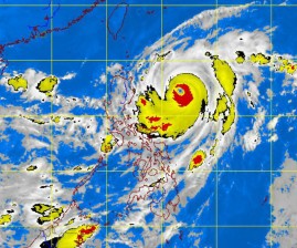
Typhoon “Lawin” is expected to make landfall Thursday in the northern part of the Philippines, but it will likely not linger.
The typhoon intensified slightly as it continued moving slowly 500 kilometers east of Casiguran, Aurora, as of Tuesday afternoon, and its diameter grew to 800 kilometers, the Philippine Atmospheric, Geophysical and Astronomical Services Administration (Pagasa) said.
Lawin was packing maximum sustained winds of 205 kph, and gustiness of 240 kph, which US meteorologists classified as a super typhoon. It was moving at 11 kph in a north-northwest direction.
Pagasa forecaster Samuel Duran said based on Lawin’s track, it would likely make landfall between the Calayan group of islands and Tuguegarao City. “But based on its track, it may leave the country’s area of responsibility by Friday or Saturday,” he added.
