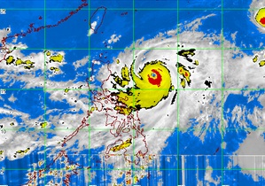
MTSAT ENHANCED-IR Satellite Image as of 5:32 p.m., 25 September 2012
MANILA, Philippines – Typhoon Lawin continued to move north northwest toward Cagayan-Batanes Area, the Philippine Atmospheric Geophysical and Astronomical Services Administration said Tuesday.
Lawin is expected to make landfall in the northern part of the Philippines by Thursday but it is not likely to linger, Pagasa said.
The typhoon intensified slightly as it continued moving slowly some 500 kilometers east of Casiguran, Aurora, Tuesday afternoon, and the breadth of the typhoon widened to 800 kilometers, according to forecasters.
Lawin was packing sustained winds of 205 kph, and gustiness of 240 kph, which US meteorologists classified as a super typhoon (Pagasa uses no such classification). It was moving at 11 kph in a north-northwest direction.
Public storm warning signal number 1, or winds with 30-60 kph, remained hoisted over Isabela, Cagayan, Calayan and Babuyan Group of Islands, Pagasa said.
Pagasa forecaster Samuel Duran said that if it continued on its current track, Lawin’s would likely make landfall between the Calayan group of islands and Tuguegarao City. “But based on its track, it may leave the country’s area of responsibility by Friday or Saturday,” he added. With a report from DJ Yap, Philippine Daily Inquirer