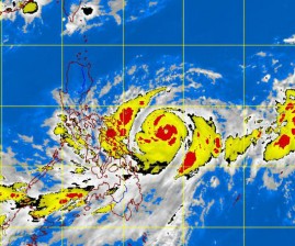
‘Lawin’ now a typhoon, nears Samar
Tropical Storm “Lawin” (international name: Jelawat) on Sunday intensified into a typhoon as it drew closer to the Samar provinces where the weather bureau hoisted storm signal No. 1.
The Philippine Atmospheric, Geophysical and Astronomical Services Administration (Pagasa) warned residents living in low-lying and mountainous areas in Eastern Samar, Western Samar and Northern Samar against possible flash floods and landslides, with heavy to intense (10 mm to 20 mm per hour) rainfall anticipated within the 600-kilometer diameter of the typhoon.
Pagasa also alerted residents in the Visayas to the possibility of landslides and flash floods triggered by occasional moderate to heavy rains.
As of 10 a.m. Sunday, the eye of Lawin was 330 km east of Borongan, Eastern Samar, packing maximum sustained winds of 120 kph near the center and gustiness of up to 150 kph and moving northwest at a speed of 7 kph.
Slow moving
Article continues after this advertisementBy 4 p.m., the eye of the slow-moving typhoon was estimated at 310 km east of Catarman, Northern Samar, and continued to gain strength over the Central Philippine Sea packing maximum sustained winds of 140 kph near the center and gustiness of up to 170 kph. The typhoon slightly veered going north-northwest but maintained its speed of 7 kph.
Article continues after this advertisementWeather forecaster Fernando Cada said there was a small chance of the typhoon making landfall if it continued northward toward Taiwan or Basco, Batanes.
Another storm
But Cada told the Philippine Daily Inquirer that they spotted another low pressure area that might also enter the Philippine area of responsibility and develop into a tropical depression on the heels of Lawin.
The typhoon is expected to enhance the habagat (southwest monsoon) and bring moderate to heavy rains to western Visayas and Mindanao while Metro Manila and the rest of Luzon will be partly cloudy with brief rain showers and thunderstorms.
Pagasa said Lawin was anticipated to be 290 km east of Virac, Catanduanes, Monday, 310 km northeast of Virac by Tuesday afternoon and 350 km east of Tuguegarao City by Wednesday afternoon. Jeannette I. Andrade with reports from Marlon Ramos, Joey A. Gabieta and Jani Arnaiz, Inquirer Visayas, and Mar S. Arguelles, Inquirer Southern Luzon
