‘Lawin’ now a tropical depression – Pagasa
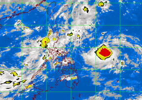
MANILA, Philippines – The active low pressure area monitored by the state weather bureau Thursday has intensified into tropical depression Lawin.
The Philippine Atmospheric Geophysical and Astronomical Services Administration said the cyclone was last spotted 910 kilometers east of Virac, Catanduanes, packing maximum sustained winds of 55kph near the center.
Although it was still too far to affect any part of the country, Pagasa said moderate to heavy rain (5 to 15 mm per hour) is expected within 300 kilometer s of Lawin.
Lawin, moving at 7 kph, was forecast to be 740 kilometers east of Virac by Friday afternoon; 570 kilometers east of Virac by Saturday afternoon and 660 kilometers east of Infanta, Quezon by Sunday afternoon.
Meanwhile, Metro Manila will experience occasional light to moderate rain except during thunderstorms.
Article continues after this advertisementLuzon and Eastern Visayas will experience occasional light to moderate rains during thunderstorms, while the rest of the country will have partly cloudy skies with brief rainshowers or thunderstorms mostly in the afternoon or evening.
Moderate to strong winds blowing from the east will prevail over northern Luzon and the coastal areas will be moderate to rough. Elsewhere, winds will be light to moderate coming from the southwest to west with slight to moderate seas, Pagasa said.
