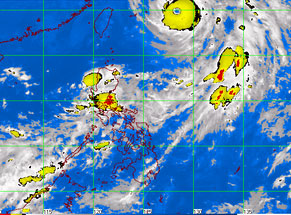
MTSAT ENHANCED-IR Satellite Image as of 8:32 p.m.
MANILA, Philippines – Despite the heavy rain that swamped Metro Manila Friday night, Typhoon “Karen” is not expected to directly affect the country as it continues to move towards Japan and will be 70 kilometers south of Okinawa by Sunday morning, the state weather bureau said in its recent bulletin.
Earlier in the day, the eye of Karen was located east of Itbayat in Batanes with maximum sustained winds of 185 kilometers per hour near the center and gustiness of up to 220 kph, the Philippine Atmospheric Geophysical Astronomical Services Administration (Pagasa) said.
As of 4 p.m., Karen was located at 680 kilometers northeast of Itbayat, Batanes or 630 kilometers east of Taiwan, Pagasa said in its 5 p.m. forecast.
It still has maximum sustained winds of 185 kilometers per hour near the center and gustiness of up to 220 kph. It is forecast to move north-northwest at 19 kph, said Pagasa.
“Karen” will continue to enhance the southwest monsoon that will bring occasional moderate to heavy rains over Central Luzon, Metro Manila, Bicol Region, CALABARZON, MIMAROPA and Western Visayas. Residents in
these areas are advised to be alert against possible flashfloods and landslides, Pagasa said.
The public and the disaster coordinating councils concerned are advised to take appropriate actions and watch for the next bulletin to be issued at 11 p.m. Saturday.