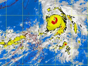
Typhoon ‘Karen’ heads to Japan
MANILA, Philippines—Typhoon “Karen” kept its strength as it was forecast to head towards Japan, the state weather bureau said Friday.
Karen was last spotted 770 kilometers northeast of Aparri in Cagayan, the Philippine Atmospheric Geophysical and Astronomical Services Administration said.
The cyclone, which was forecast to move north at 15 kilometers per hour, was packing maximum sustained winds of 185 kph near the center and gustiness of up to 220 kph.
The Joint Typhoon Warning Center based in Hawaii has classified Karen (international name Sanba) as a super typhoon or very strong tropical cyclone equivalent of a category 4 or 5 hurricane.
Karen did not make landfall in the Philippines.
Article continues after this advertisementOccasional to moderate heavy rains will be experienced in Central Luzon, Calabarzon, Mimaropa and Bicol region which may trigger flashfloods and landslides. Visayas and Northern Luzon will be cloudy with scattered light to moderate rains. Mindanao will have partly cloudy skies with isolated rains or thunderstorms in the evening.
Article continues after this advertisementMeanwhile, Metro Manila will be cloudy with occasional moderate to heavy rains and thunderstorms.
Originally posted at 12:43 p.m.
