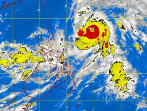
MANILA, Philippines — Typhoon “Karen” has slightly intensified anew as it moved north-northwest, the Philippine Atmospheric Geophysical and Astronomical Services Administration said Friday.
Karen was seen 740 kilometers east of Tuguegarao City early morning packing maximum sustained winds of 185 kph near the center and gustiness of up to 220 kph. It was forecast to move north-northwest at 15 kph.
Moderate to heavy rains and thunderstorms will be experienced over Calabarzon, Mimaropa, Bicol Region and Western Visayas, while the rest of the country will have partly cloudy skies with brief rainshowers or thunderstorms.
Metro Manila will be cloudy with moderate to heavy rains and thunderstorms. Moderate to strong winds blowing from the southwest and Manila Bay will be moderate to rough.
Fishing boats and small vessels are advised not to venture on seaboards of Luzon and Visayas and larger vessels are alerted against big waves due to gale warning issued by the state weather bureau.
