Tropical Storm ‘Karen’ may not hit land—Pagasa
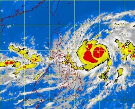
Tropical Storm “Karen” intensified and continued its movement over the Eastern Philippine Sea while a low pressure area (LPA) remained over the West Philippine Sea, the state weather bureau said Wednesday.
At 4 p.m., the eye of the storm was observed based on satellite and surface data at 640 kilometers east of Virac, Catanduanes, while the LPA was estimated at 250 km west of Zambales, the Philippine Atmospheric, Geophysical and Astronomical Services Administration (Pagasa) said.
Karen was packing maximum sustained winds of 85 kph near the center and gustiness of up to 100 kph. It is forecast to move northwest at 15 kph, Pagasa said in an advisory.
If its movement is consistent, Karen may not make landfall in any part of the country, the weather bureau said. On the other hand, there is a chance the LPA may turn into a tropical cyclone as it is over the sea, it added.
Karen may leave the Philippine area of responsibility by the weekend.
