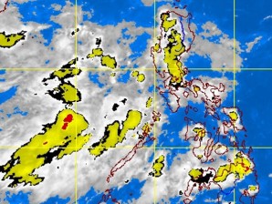
At 10 a.m., the eye of the storm was located some 620 kilometers east of Borongan, Eastern Samar, while the low pressure area was estimated at 250 km west of Zambales, the Philippine Atmospheric, Geophysical and Astronomical Services Administration said.
Karen was packing maximum sustained winds of 85 kph near the center, compared to its 65-kph peak winds Tuesday, and gusting up to 100 kph. It was forecast to move northwest at 15 kph, Pagasa said in an advisory.
If it stays on that track, Karen may not make landfall in any part of the country, the weather bureau said. On the other hand, there is a chance the low pressure area may turn into a tropical cyclone, it added.
Karen may leave the Philippine area of responsibility by weekend. It is expected to be at 770 km east of Infanta, Quezon by Thursday morning, 620 km east of Tuguegarao City by Friday morning, and 500 km east of Itbayat, Batanes, by Saturday morning.
The storm will bring moderate to heavy rains (10 to 20 mm per hour) to places within 275 kilometers of its center, Pagasa said.
The weather bureau advised fishing boats and other small seacraft not to venture out to sea off the eastern coasts of the Visayas and Mindanao.
No public storm signal had been raised as of midday Wednesday.
Metro Manila is forecast to have partly cloudy to cloudy skies with light to moderate rains. Occasional moderate to heavy rains will be experienced over Eastern Visayas, Zamboanga and Caraga regions, Pagasa said, warning of the possibility of flash floods and landslides in those places.
Pagasa said the rest of the country will have scattered light to moderate rains.