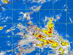
A new shallow low pressure area (SLPA) has developed within the country’s area of responsibility just as an earlier one completely dissipated Monday morning.
The new SLPA was spotted based on satellite and surface data at 850 kilometers east of the Bicol region as of 2 p.m. Monday.
The Philippine Atmospheric, Geophysical and Astronomical Services Administration (Pagasa) has been monitoring over the weekend the earlier SLPA which was estimated at 470 km east of Borongan, Eastern Samar, at 2 a.m. Monday but the SLPA weakened and completely dissipated by 10 a.m. Monday.
Weather forecaster Gladys Saludes said that although the effect of the habagat (southwest monsoon) has weakened, it is still expected to bring scattered light to moderate rain showers (one to five mm per hour) and thunderstorms over the western section of southern Luzon.
The western section of southern Luzon includes Metro Manila, Palawan, the Mindoro provinces, Cavite, Laguna and Batangas.
The Visayas and Mindanao will experience mostly cloudy skies with scattered rainshowers and thunderstorms.
Saludes told the Philippine Daily Inquirer that the earlier LPA seemed to gain strength as it moved northward but by 2 a.m. Monday, it had become shallow and displayed poor wind circulation. She said that eight hours later the SLPA dissipated, with no detected circulation where it was last monitored.
But a new SLPA formed east of the Bicol region Monday afternoon.
Weather forecaster Bernie de Leon told the Inquirer that the new SLPA is not anticipated to directly affect the country because of its distance but said the enhanced southwest monsoon would bring rains over southern Luzon.
