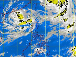
MANILA, Philippines—While Typhoon “Julian” (international name: Bolaven) exited the country on Sunday and moved to southern Japan, Typhoon “Igme” (Tembin) appears to be headed back to the Philippines anytime between Monday and Tuesday.
The Philippine Atmospheric, Geophysical and Astronomical Services Administration (Pagasa) warned of possible flashfloods and landslides in northern Luzon as “Julian” and “Igme,” although outside the Philippine area of responsibility (PAR), are expected to enhance the habagat (southwest monsoon) and bring occasional to frequent rains over northern and Central Luzon.
The rest of Luzon, including Metro Manila, will experience mostly cloudy skies with scattered rain showers and thunderstorms.
Pagasa said that as of 1 p.m. Sunday, Igme was almost stationary at 460 kilometers northwest of Laoag City although still outside the PAR.
But by 4 p.m., it had moved south southeast at 7 kilometers per hour and was at 490 km west of Basco, Batanes, with maximum sustained winds of 140 kph near the center and gustiness of up to 170 kph.
Weather forecaster Jory Loiz told the Inquirer that Igme was hardly moving because of its continuing interaction with Julian.
“Typhoon Julian is preventing its movement,” Loiz explained, noting that while Igme was almost stationary, it was apparently growing in intensity.
Julian left the PAR at 4 a.m. Sunday and was last estimated to be at 850 km northeast of Basco, moving northwest at 15 kph towards Japan. Julian packed maximum sustained winds of 175 kph near the center with gustiness at 210 kph.
