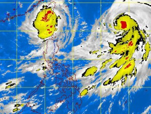
MANILA, Philippines – Typhoon “Igme” has made landfall over Taiwan but was seen to make a counter clockwise looping motion for at least two days due to the pull of typhoon Julian, the state weather bureau said on Friday.
Public storm signal warning signal number 2 remained in Batanes Group of Islands and signal number 1 in Calayan and Babuyan Group of Islands, the Philippine Atmospheric Geophysical and Astronomical Services Administration said.
Typhoon “Julian”, the new cyclone in the Philippine territory, was seen 1,050km east of Basco, Batanes, packing maximum sustained winds of 150kph near the center and gustiness of up to 185 kph. It was moving west northwest at 15kph.
Both cyclones will affect Northern and Western Luzon, said Pagasa in its special weather outlook.
National Capital Region will be generally with light rainshowers until Sunday. Rainfall amount in Metro Manila will be insignificant due to weak southwest monsoon.
Meanwhile, moderate to heavy rains are expected within 600km of Julian. It is also expected to enhance the southwest monsoon to bring rains in Visayas and Mindanao.
Meanwhile, “Igme” was last seen 24kilometers northwest if Basco, Batanes, packing maximum sustained winds of 140kph near the centerband gustiness of up to 170 kph. It was moving west northwest at 15 kph.
Southern Luzon, Visayas and Mindanao will experience rains from an enhanced southwest monsoon caused by “Igme.”
In its gale warning, Pagasa said winds of “Igme” may affect northern and eastern Luzon.
Fishing boats and small vessel were asked not to venture into the sea while larger\ vessels were alerted against big waves.
