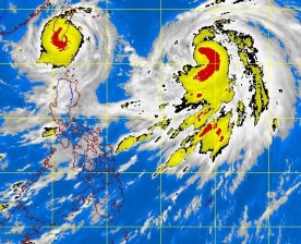
Departing Typhoon “Igme” may just stage a comeback, pulled back into the Philippine area of responsibility by incoming Typhoon “Julian,” thereby triggering the Fujiwhara effect, or the interaction between two storms, the weather bureau said Thursday.
On Thursday, Igme (international name: “Tembin”) maintained its strength as it moved closer to Batanes en route to Taiwan, but Julian (“Bolaven”), which was expected to strike extreme northern Luzon later in the day, might pull it back, weather forecaster Gladys Saludes said.
“That is a scenario of one of our models which we see happening from Friday evening up to Saturday,” said Saludes of the Philippine Atmospheric, Geophysical and Astronomical Services Administration (Pagasa).
The Fujiwhara effect is a phenomenon described by the US National Weather Service as the tendency of two storms to join together and move around a common pivot.
If this happens, Igme may weaken and end up being swallowed by Julian, which will in turn become stronger, Saludes said.
But it is also possible the two weather disturbances will not join up, since Igme is headed toward Taiwan, while Julian is projected to move toward Japan, she said.
At midday Thursday, satellite and surface data showed Igme’s eye at 260 kilometers north northeast of Basco, Batanes, moving westward at a slow 7 kilometers per hour and packing maximum sustained winds of 130 kph.—DJ Yap
