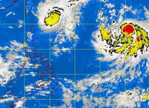
MANILA, Philippines—All public storm signals were lowered Tuesday, except in the country’s northernmost islands, as Typhoon Igme continued moving slowly northward, the state weather bureau said.
As of mid-morning Tuesday, Batanes province and the Calayan and Babuyan groups of islands were still under Storm Signal No. 1, lashed by 30-60 kph winds, the Philippine Atmospheric, Geophysical and Astronomical Services Administration (Pagasa) said.
At 10 a.m., the typhoon was located 310 kilometers east of Basco, Batanes, packing maximum sustained winds of 165 kph near the center, and gusts of up to 200 kph, Pagasa said.
Igme was moving north at 11 kph, Pagasa said in a bulletin. Pagasa rainfall specialist Sharon Arruejo said a high pressure area over China was causing Igme to move slowly.
She said Igme, which made no landfall in the Philippines, might be out of the country by early Friday.
Meanwhile, Arruejo said a brewing tropical cyclone east of Luzon was almost parallel with Igme and, thus, not expected to directly strike the Philippines. If it enters the country’s area of responsibility, it would be named Julian.
Pagasa said Igme will continue to generate heavy rainfall of 10-25 millimeters in areas within 275 kilometers of the typhoon’s eye.
It is expected to enhance the southwest monsoon, which will bring light to moderate rains over Luzon, especially the western section, including Metro Manila, Pangasinan, Zambales, Bataan, Batangas and Mindoro.
Fishing boats and other small seacraft on the eastern coast of Central and Southern Luzon were warned not to venture out to sea due to big waves churned up by the typhoon and the southwest monsoon, Pagasa said.
In its outlook, Pagasa said, Cagayan, including the Calayan and Babuyan groups of islands, and Batanes province will experience rains with gusty winds, and the seas around them will be rough to very rough.
The rest of Luzon, the weather bureau said, will be mostly cloudy with scattered rain showers and thunderstorms becoming cloudy with widespread rains over the rest of northern Luzon and the western section of Central Luzon, which may trigger flash floods and landslides.
Visayas and Mindanao will have partly cloudy to cloudy skies with isolated rain showers or thunderstorms. Moderate to strong winds blowing from the northwest to west will prevail over the rest of northern Luzon and coming from the southwest over the rest of the country, Pagasa said.
Coastal waters along these areas will be moderate to rough, it added.
