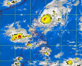
The weather bureau placed Cagayan and Isabela under public Storm Signal No. 1 even as “Igme” (international name: Tembin) skirted northern Luzon on Monday but intensified into a typhoon.
Isabela officials, however, reported only spurts of rainfall, with the sun peeking in the morning.
“Igme is moving northward, away from Isabela, but its presence may still give us monsoon rains,” said provincial administrator Noel Manuel Lopez.
It could develop into a supertyphoon the longer it stays over the ocean, the Philippine Atmospheric, Geophysical and Astronomical Services Administration (Pagasa) said in Manila. The agency, however, gave assurance that it was unlikely to make landfall.
As of 4 p.m. on Monday, the typhoon was packing maximum sustained winds of 130 kilometers per hour near the center and gustiness of up to 160 km per hour, weather forecaster Buddy Javier told the Inquirer. It was hardly moving when it was spotted at 310 km east of Aparri, Cagayan, and its speed could not be measured, he added.
Igme was expected to enhance the “habagat” (southwest monsoon) which will bring light to moderate rains over Luzon, particularly Pangasinan, Zambales, Bataan and Mindoro.
Pagasa said Igme would be 245 km east-northeast of Basco, Batanes, tomorrow afternoon and 285 km north-northwest of Basco on Thursday.
In Isabela, officials of the Provincial Disaster Risk Reduction and Management Council (PDRRMC) said they will stay on alert even as the storm was forecast to head toward the sea in northern Cagayan.
Ramil Tuppil, Pagasa weather specialist in Isabela, said Igme would not hit land and the Sierra Madre mountains have been protecting Isabela from strong winds.
Lopez said the PDRRMC and provincial officials have been monitoring online weather bulletins issued not only by Pagasa but by other agencies based in the United States, Japan and China to get accurate information on the storm’s track.
He said relief goods had been prepared in the coastal towns of Isabela facing the Pacific Ocean and in the remote towns of San Agustin, Jones, San Guillermo and Echague.
Ambulances and medical and search-and-rescue equipment have been readied for deployment, he said.
The PDRRMC has also formed teams to monitor water levels in the dams and waterways.
In Pangasinan, San Roque Dam in San Manuel town opened its spillway gates Sunday night as Igme approached Cagayan.
In an advisory, Tom Valdez, San Roque Power Corp. vice president for corporate social responsibility, said the flood forecasting and warning system for dam operations of National Power Corp. (Napocor) had advised the firm to open Gate 2A at 10 p.m. and release water at the rate of 75 cubic meters per second.
The spillway gates were closed on Aug. 17, after the water elevation went down to 280 meters above sea level.
On Monday noon, the reading was 281.19 masl. One more gate was opened at 8 a.m. as the volume of water coming into the dam increased.
Valdez said the dam was discharging at 483 cms while taking in water at the rate of 414 cms from the excess released by Binga Dam in Benguet and run-off water from the surrounding mountains. At 6 a.m. Monday, Binga Dam, which is upstream of the Agno River, had two spillway gates open, spilling water at 334 cms.
In Rosales town, the Agno River Flood Forecasting and Warning Center (ARFFWC) warned residents along the major river systems to be alert for floods.
In a bulletin issued at 4 a.m. on Monday, the ARFFWC said flooding was expected to persist in the low-lying areas of Sta. Barbara, Calasiao, Binmaley, Binalonan and Malasiqui towns, and the cities of Dagupan and Urdaneta because of the critical level of the Sinocalan, Ingalera and Tagamusing rivers.
Flooding is also expected to hit low-lying areas in nine central and northern Pangasinan towns because of the slow rise of water levels at the Bued, Patalan, Angalacan and Aloragat rivers. Reports from Villamor Visaya Jr. and Gabriel Cardinoza, Inquirer Northern Luzon
