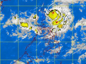
‘Igme’ threatens Cagayan, Isabela
It may not be a sunny long weekend afterall.
Although clear skies were earlier forecast for the holiday, an active low pressure area east of northern Luzon developed Sunday into Tropical Depression “Igme,” prompting weather forecasters to hoist public storm warning signal No. 1 over two provinces.
The Philippine Atmospheric, Geophysical and Astronomical Services Administration
(Pagasa) raised the storm signal over Isabela and Cagayan provinces. Northern Luzon
residents, especially in low-lying and mountainous areas, were warned against
Article continues after this advertisementpossible flashfloods and landslides.
Article continues after this advertisementCagayan and Isabela will experience rains and gusty winds, from 45 to 60 kilometers per hour, and their coastal waters will be rough to very rough, Pagasa said.
The National Disaster Risk Reduction and Management Council (NDRRMC) on Sunday placed all its offices in northern Luzon on red alert.
“We are prepared for this. While we have not ordered a preemptive evacuation, we have deployed our people and warned the residents in the areas which could be affected by Igme,” said NDRRMC Executive Director Benito Ramos.
Enhance monsoon
Igme is anticipated to enhance the habagat (southwest monsoon) and bring rains over the rest of northern Luzon, particularly Benguet, Baguio City, Pangasinan, La Union, and the Ilocos region. The western section of Central and southern Luzon, including Metro Manila, is expected to be cloudy with scattered rainshowers or thunderstorms.
Fishing boats and other small vessels were warned against venturing out into the eastern seaboards of Central and southern Luzon (Aurora, Quezon and Bicol region). Even large sea vessels have been alerted to the possibility of big waves and monsoon surges which could make the sea rough to very rough.
At 4 p.m. Sunday, Igme was estimated based on satellite and surface data at 315 kilometers east southeast of Aparri, Cagayan, packing maximum sustained winds of 65 kph near the center and gustiness of up to 80 kph. It was slowly moving northward and veering away from its previous westward trek.
An hour earlier, supervising weather forecaster Rene Paciente noticed that the slow-moving tropical storm had started to “loop.” From its westward trek, it started moving towards the southwest but is anticipated soon to move up towards Taiwan.
“This means that there is no other weather system dictating or steering its movement,” Paciente explained. He added that while Igme is not anticipated to make landfall, the tropical storm’s slow movement may cause it to intensify and enhance the habagat.
But forecaster Aldczar Aurelio said the almost-stationary Igme could intensify further into a typhoon.
“The slower a storm, the more intense it gets,” he told the Inquirer.
The weather bureau placed the estimated amount of rainfall at moderate to heavy (five to ten mm per hour) within the 400 kilometer-diameter of the weather system.
The tropical depression is expected to be at 320 km east southeast of Aparri by Monday afternoon and 400 km east-northeast of the province by Tuesday. By Wednesday, it would have moved to 300 km north of Aparri or over Basco, Batanes.
Visayas, Mindanao
The Visayas and Mindanao will have partly cloudy to cloudy skies with isolated rain showers or thunderstorms. Moderate to strong winds blowing from the southwest and west will prevail over the Visayas and the rest of Luzon. The coastal waters in these areas will be moderate to rough. Elsewhere, winds will be light to moderate coming from the southwest with slight to moderate seas.
In an Aug. 17 statement, Science and Technology Secretary Mario Montejo reported “generally sunny, fair weather” was anticipated for the extended weekend due to the holidays on Monday (Eid’l Fitr) and Tuesday (Ninoy Aquino Day).
“It is also the best time to do and hang the laundry, and wash off the mud and dirt that built up during the recent monsoon rains and Typhoon Helen,” Montejo had said.
This was based on the weather bureau’s five-day weather outlook which, he said, “does not indicate any tropical cyclone within the Philippine area of responsibility.”
Pagasa, however, did mention that it was keeping watch over an active low pressure area east of Aparri.
The Japan Meteorological Agency on Saturday had classified the disturbance as a tropical depression. With a report from Marlon Ramos
