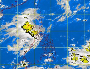
But rains returned with a vengeance in the afternoon, raising flood levels over again in many parts of Metro Manila.
In a matter of five hours, the weather bureau’s warning changed from yellow to green and then to red.
Under a red warning, the rain falls at a rate of 30 millimeter per hour, which should prompt an evacuation for residents in low-lying areas.
The Philippine Atmospheric, Geophysical and Astronomical Services Administration (Pagasa) raised the warning over Metro Manila from green to red in just an hour.
By 4:30 p.m., the weather bureau elevated the green warning to red as a result of continuing downpour over the National Capital Region.
“We thought the weather was improving already when there was sunshine,” said weather bureau forecaster Bernard Punzalan.
Punzalan noted a slight weakening of the “habagat” (southwest monsoon) with Tropical Storm “Haikui” making landfall on Shanghai, China, Wednesday morning, moving farther away from the Philippine area of responsibility.
Improve slightly by weekend
Punzalan said the weather was expected to slightly improve before the weekend but light to moderate rains were still to be expected in portions of Batangas.
Intermittent moderate to heavy but less frequents rains will be experienced until Thursday in areas of Pangasinan, Nueva Ecija, Pampanga, Tarlac, Bulacan, Bataan, Rizal, Cavite and Metro Manila.
Light to moderate rains means the amount of rainfall would be 2.5 mm to 5 mm per hour while intermittent moderate to heavy would be 5 mm to 10 mm per hour.
Punzalan said the volume of rainfall on Tuesday was 39.2 mm per hour compared with that of Tropical Storm “Ondoy” at 56.85 mm per hour at its peak that inundated Metro Manila in 2009 and killed more than 400 people.
In its forecast issued at 5 p.m., the weather bureau said Luzon would experience occasional rains becoming frequent over the western section, including Metro Manila. The Visayas and Mindanao will be partly cloudy to cloudy with isolated rain showers or thunderstorms.
Strong to gale force winds are expected to affect the western seaboards of Luzon where seas are expected to be rough to very rough. Fishing boats and other small sea craft are advised not to venture out into the sea while larger sea vessels have been alerted against big waves.
Embedded thunderstorms
In Manila and Marikina City, the volume of rainfall was recorded at 30 mm to 50 mm per hour. It was 15 mm to 30 mm per hour in Caloocan, Malabon, Navotas, Taguig and Pasay Cities.
The rest of the capital recorded moderate to heavy rainfall.
Pagasa recorded torrential rainfall of 30 mm to 50 mm per hour in Manila, Pasig, Mandaluyong and San Juan Cities while heavy to intense rainfall (15 mm to 25 mm per hour) was recorded in Pasay, Marikina, Quezon, Taguig and Makati Cities as well as in the northern portion of Caloocan City.
Moderate to heavy rainfall of 7.5 mm to 15 mm per hour was recorded in the rest of Metro Manila.
Weather forecaster Gener Quitlong attributed the heavy downpour to the series of thunderstorms embedded in the southwest monsoon.
La Mesa reservoir
In Quezon City, the La Mesa reservoir continued to spill water on Wednesday, flooding communities.
Water from La Mesa goes into the Tullahan River, which flows through the northern part of Quezon City, including the Fairview area, as well as the cities of Malabon, Valenzuela and Caloocan. The river drains into Manila Bay.
The water elevation at La Mesa declined steadily for most of the day but showed signs it may rise again toward the evening, according to Manila Water Company Inc.
The reservoir starts to spill water after 80.15 m. With a report from Riza T. Olchondra