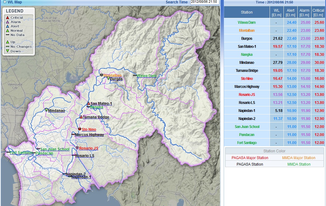
MANILA, Philippines – Water level in some rivers and waterways in Metro Manila has reached critical mark as rains spawned by the southwest monsoon and a shallow low pressure area continued to pound the region, according to the state-run weather bureau’s water level monitoring system.
As of 9 p.m., the water level at the Tumana bridge in Marikina hit 18.95 meters. An hour ago, the water level recorded was 18.66 meters and then it rose to 18.86 meters in the next half hour.
The critical water level at Tumana bridge is 18.30 meters, according to the Philippine Atmospheric, Geophysical and Astronomical Services Administration (Pagasa) Flood Forecasting and Warning System (FFWS).
It was the same case for the Sto Nino water level measuring station. The water level was measured at 15.55 meters around 7 p.m., then rose to 16.13 meters by 8 p.m. At 8:30 p.m., it went up to 16.32 meters.
As of 9 p.m. its water level was at 16.40 meters, almost half a meter above the critical level of 16 meters, according to the FFWS.
The water level along Marcos Highway also rose quickly within two hours. At 7 p.m. it recorded a water level of 14.69 meters, then rose to 15.02 by 8 p.m. It continued to rise to 15.17 by 8:30 p.m., and as of 9 p.m. the water level was at 15.24 meters, above the critical water level of 14.90 meters.
The San Mateo-1 monitoring station recorded a water level of 19.45 meters as of 9 p.m., more than a meter above the critical water level of 18.30 meters.
Pagasa’s FFWS is a new system that obtains water level data from several water monitoring station in Metro Manila’s riverways and updates them online every 10 minutes. It can be found at https://121.58.193.220:8080/html/wl/wl_map.html
