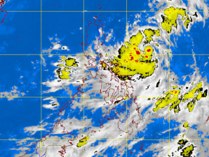
MANILA, Philippines – Public storm signal warnings remained as typhoon Gener moved slowly north, the state weather bureau said Tuesday.
Still posing a “threat” to extreme northern Luzon, public storm signal warning number 3 remained hoisted in Batanes Group of Islands, while public storm signal number 2 remained in Cagayan including Calayan and Babuyan Group of Islands, the Philippine Atmospheric Geophysical and Astronomical Services Administration said.
Meanwhile, public storm signal number one was still up in Isabela, Kalinga and Apayao.
As of 4 p.m. the eye typhoon Gener was located 260 kilometers east northeast of Basco, Batanes, with maximum sustained winds of 120 kph near the center and gustiness of up to 150 kph. It was moving north at 7 kph.
Residents living in low lying and mountainous areas were alerted against possible flashfloods and landslides.
Likewise, those living in coastal areas under public storm warning signal 3 and 2 were alerted against big waves or storm surges generated by this tropical cyclone.
Fishing boats and other small seacraft were advised not to venture out into the Seaboard of Luzon and Visayas due to the combined effect of typhoon “Gener” and the southwest monsoon. Typhoon “Gener” was expected to enhance the southwest monsoon that will bring rains and moderate to strong winds over Luzon and Visayas especially the western section.
Estimated rainfall amount is from 10 – 20 mm per hour (heavy – intense) within the 700 km diameter of the typhoon, Pagasa said.
Typhoon Gener was forecast to be 360 km northeast of Basco, Batanes by Wednesday afternoon; 500 km north of Basco, Batanes or out of the Philippine area of responsibility by Thursday afternoon.


