
Buddy Javier, weather forecaster of the Philippine Atmospheric Geophysical and Astronomical Services Administration, told INQUIRER.net that although the weather disturbance may dissipate, forecast models indicated that it has bigger chances to become a tropical depression by Friday or sooner.
As of 2 p.m., the LPA was seen 830 kilometers east of Central Luzon.
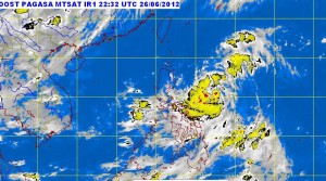
“Based on our models, parts of Bicol and Visayas will be cloudy due to the low pressure area,” he said.
Once it becomes a cyclone it will be named Ferdie.
Meanwhile, Southern Luzon, Visayas and Mindanao will experience mostly cloudy skies with scattered rainshowers and thunderstorms becoming cloudy with widespread rains over Bicol region and Eastern Visayas which may trigger flashfloods and landslides.
The rest of the country will be partly cloudy to cloudy with isolated rainshowers or thunderstorms, Pagasa said.
Light to moderate winds blowing from the southwest to northwest will prevail over Northern and Central Luzon and coming from the southwest to west over the rest of the country. The coastal waters throughout the archipelago will be slight to moderate.