Tropical Storm ‘Enteng’: Hello and good-bye
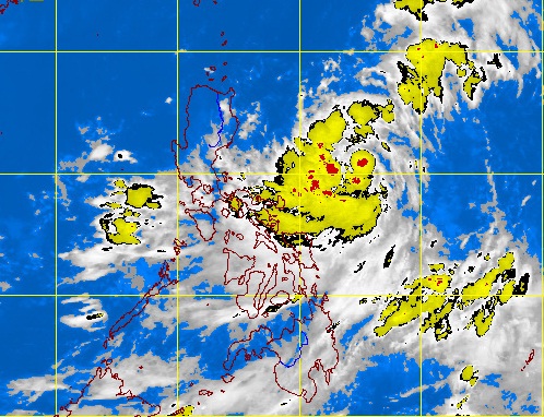
MTSAT ENHANCED-IR Satellite Image 4:32 a.m., 18 July 2012
Tropical Storm “Enteng” crossed the Philippine area of responsibility (PAR) Monday night but only briefly, posing no threat at all to the archipelago.
The storm hardly made its presence felt, swirling into PAR before 8 p.m. Monday and exiting at 12 midnight, said forecasters of the Philippine Atmospheric Geophysical and Astronomical Services Administration.
“No effect at all. It didn’t even enhance the southwest monsoon,” forecaster Mario Palafox said by phone.
From a tropical depression over the Pacific Ocean, it intensified into a storm when it swirled in east of Taiwan, skimming the northeastern corner of PAR. Taiwan is within PAR, the area where the weather bureau monitors cyclones and issues warnings.
By 2 a.m. Tuesday, the storm was estimated to be 1,100 kilometers east northeast of Basco, Batanes, packing maximum winds of 65 kilometers per hour, and gusting up to 80 kph. It was forecast to move west northwest toward Japan.
Article continues after this advertisementPrevious low pressure areas (LPAs) dumped more rain and brought more damage to some parts of the archipelago. An average of 20 cyclones crosses the archipelago from the Pacific Ocean.
A weak southwest monsoon would bring cloudy skies with scattered rain showers and thunderstorms over over Southern Luzon and Visayas. The rest of the country would be partly to cloudy with isolated rain showers or thunderstorms, the bureau said. TJ Burgonio