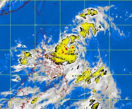
MANILA, Philippines – A tropical depression was seen off Basco, Batanes, Monday, but will stay only for a few hours and will not make landfall, the state weather bureau said.
As of 2 p.m., tropical depression Khanun was plotted 1,340 kilometers east northeast of Basco with maximum winds of 55 kilometers per hour. It was forecast to move west northwest at 19 kph, the Philippine Atmospheric Geophysical and Astronomical Services Administration said.
Once it enters the country, it will be named Enteng.
Manny Mendoza of Pagasa said it will only stay briefly within the Philippine territory, and will exit the country by Tuesday morning.
“It would only brush the northern edge of Batanes,” he added.
Meanwhile, a weak southwest monsoon affecting the western sections of Northern and Central Luzon, will enhance rains whipped up by the tropical depression.
The western sections of Northern and Central Luzon will experience mostly cloudy skies with scattered rainshowers and thunderstorms. The rest of the country will be partly cloudy to cloudy with isolated rainshowers or thunderstorms, Pagasa said.
Light to moderate south-westerly winds will prevail over the entire archipelago and the coastal waters will be slight to moderate.
