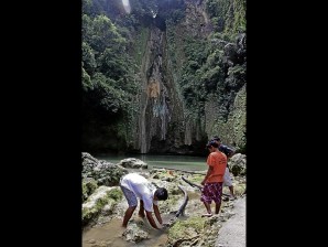
RESIDENTS of the village of Mantayupan in Barili, Cebu, try to divert water to fish ponds after a sinkhole suddenly formed in and dried up a river that runs through the village. The phenomenon also dried up the Mantayupan Falls shown here looking like a cliff instead of a waterfall. CARMEL MATUS/inquirer visayas
BARILI, Cebu—The Mantayupan Falls now looks like a dry cliff after water that used to cascade from it has disappeared.
The drying up of the town’s tourist destination occurred after most of the water from the Mantayupan River was sucked by a sinkhole that was reported on July 11.
Barili Mayor Teresito Mariñas is appealing for an immediate solution since the incident has hurt the livelihood of residents, a mini hydropower plant in the town, and the tourism industry.
The bizarre phenomenon also comes at a bad time as the town is expecting an influx of tourists during its annual fiesta, which will be celebrated from July 17 to July 26.
Located 61 km from Cebu City, the Mantayupan Falls has become an alternate tourist destination after the Kawasan Falls, also in Barili, was shut down in May by the provincial government to remove illegal cottages and structures.
Farmers reported on July 11 a sinkhole at a portion of Mantayupan River in the boundary of Barangays Nasipit and Mantayupan. The water level in the river slowly dropped.
On Friday, residents were surprised to find that a portion of the river was reduced to small water puddles. But the water remained at the hole which looked like a jacuzzi with water gushing out from underneath.
Since the source of water of Mantayupan Falls—the river—has dried up, the falls has run out of water, too.
A team from the Mines and Geosciences Bureau in Central Visayas could not measure the depth of the sinkhole since their measuring device could only reach a depth of up to 4.5 meters.
Senior geologist Abraham Lucero said the sinkhole might have been caused by heavy rains in the areas during recent days.
He said the volume of rain must have flooded or saturated sand and gravel in the riverbed, causing the ground to warp or cave in.
Mechanized sand and gravel extraction in the area may have also triggered the sinkhole, Lucero said.
He said sinkholes are common in the province where 70 percent of the land is made up of limestones, which break easily.
“Perhaps, the cavities were so thin that these caved in from underneath,” he said.
To determine the radius of the hole, Lucero said geologists would have to borrow from the MGB central office in Manila a ground penetrating radar system (GPRS), which can measure three dimensions of the sinkhole that he said could be up to 30 meters deep.
Lucero advised the municipal government to cordon off the area to prevent people from accidentally falling into the sinkhole.
An 80-year-old resident, Mines Estomo, said there was a cave inside the river where water used to flow out from.
Estomo said that during a typhoon in the 1990s, a landslide covered the cave, diverting water that comes out of it to where the sinkhole is now found.
He said he believed the ongoing extraction of sand and gravel could have led to the reopening of the cave.
The river is the source of water for rice fields, fishponds and a mini hydro plant in the town, which suffered a drastic reduction of water supply.
Mayor Mariñas said officials were studying two options—install pipes or use sandbags to divert water to the falls.
“This is a serious concern that needs an immediate solution,” said the mayor.